Our gut feeling may tell us that some parts of Penang appear more landslide prone than others, but are there any scientific or geological grounds for such concern?

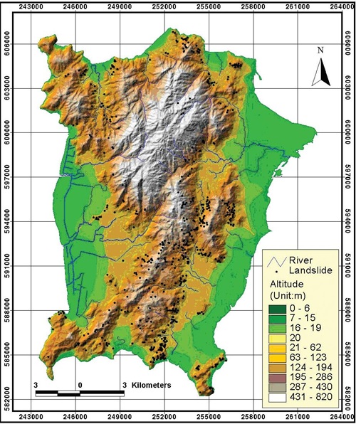
Landslide hazard map – Maps from paper by Lee and Pradhan
Here are a couple of maps reproduced from a paper on ‘Probabilistic landslide hazards and risk mapping on Penang Island’ by Saro Lee (Korea Institute of Geoscience and Mineral Resources) and Biswajeet Pradhan.
This paper looks at landslide hazards and comes up with a landslide risk analysis of Penang Island using Geographic Information System (GIS) and remote sensing data. From this a hazard map (above) was produced with a high degree of accurarcy, the authors say.
Extract from the paper:
There are ten landslide inducing parameters which are considered for landslide hazard analysis. These parameters are:
- topographic slope,
- aspect,
- curvature and
- distance from drainage, all derived from the topographic database;
- geology and
- distance from lineament, derived from the geologic database;
- landuse from Landsat satellite images;
- soil from the soil database;
- precipitation amount, derived from the rainfall database; and
- the vegetation index value from SPOT satellite images.

Hill shaded map showing the locations of landslides
As seen above, there are so many factors that determine the susceptbility to landslides. Among these factors, the authors note:
The relationship between landslide occurrence and slope (table 2) shows that steeper slopes have greater landslide probabilities. Below a slope of 15◦, the frequency ratio was 0.20, which indicates a very low probability of landslide occurrence. For slopes above 16◦, the ratio was >1, which indicates a high probability of landslide occurrence. As the slope angle increases, then the shear stress in the soil or other unconsolidated material generally increases.
Well, we can’t say we haven’t been warned to take all this into account in our land-use zoning and regulatory management.
| Please help to support this blog if you can. Read the commenting guidlelines for this blog. |
Could this study have over-counted “land slides” by counting hillside denuding for agricultural use?
Denuding is bad, but could this affect the accuracy of landslide counts? Is each of so many sites really verified by eye and field work?
The study said
“Landslide locations were detected
by aerial photo interpretation and further verified
by fieldwork. These landslides can be seen in
aerial photographs by interpreting breaks in the
forest canopy, bare soil, and other typical geomorphic
characteristics of landslide scars.”