
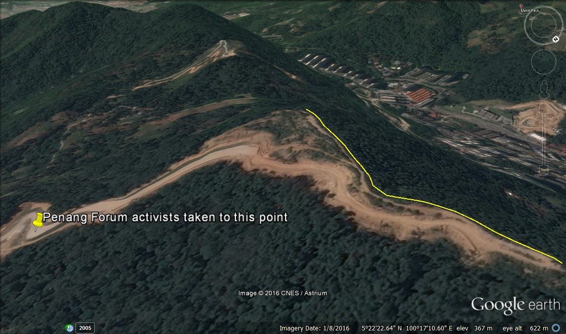
The above satellite image is of the 1.5km-long flattened summit of Botak Hill, which Penang Forum activists were not taken to see. Instead the four-wheel drives stopped at the boundary of the plot of land, well below the top (see the yellow pin in the photo below). Why were they not taken to the top?
The photo below is a 360-degree shot of the summit in early 2014 taken by an avid hiker.

The hiker has published more photographs on his blog of the devastation on Botak Hill along trails leading to the summit. Vigilant hikers like him are the guardians of our hills.
Also check out the write-up by Penang From with more than three dozen photographs. The scale of the destruction of the hill is breathtaking.
We have to be vigilant now because the Penang Structure Plan is due for review (five years after it was gazetted in 2007). There is a real concern that the 250-feet threshold, beyond which no property development is allowed, could be raised if there is intense pressure from lobby groups.
| Please help to support this blog if you can. Read the commenting guidlelines for this blog. |
Ti$$$$ the suspected CAT’s penchant for Raping The Virgin Hills: If you want to RAPE (the Penang hills), pay up first. We will ‘YES’ it first by legal means subjectively – by rezoning the hill quietly. If you can’t wait to RAPE, but have to do it, do so quietly. No groaning sound. When the RAPE is found out, we will pretend not to know – “we can’t be everywhere to monitor the hills” will be out SOP! We will deny first, will then blame somebody (at the B-End) & will also support the outcry for CAT justice against RAPE… Read more »
Rezoning can only be approved by the chair person of the state planning committee spc i.e. the CM himself..so basically the cm approved turning the hill into residential and giving the green light to other hill land owners…
Penang Forum activists could check up Sasaki Associates’ master plan for Iskandar Forest City focusing on mixed use green development, across 4 man-made islands between Johor and Singapore:
http://www.archdaily.com/781247/sasakis-forest-city-master-plan-in-iskandar-malaysia-stretches-across-4-islands
The development strategy involves both a mixed-used, walkable approach, along with a “symbiotic relationship” between the built and natural environments. The development will be connected to the larger region via a light rail and ferry, linking to planned extensions of Singapore and Malaysia’s transit infrastructure.
Today’s Kwong Wah Jit Poh has a detailed article on the upcoming development in Air Itam, dubbed as a ‘golden site’ for developers:
http://www.kwongwah.com.my/?p=88050
What kind of development do they have in mind?
nothing wrong with rezone to housing. even if its is hill land the owner can still botak the trees and scrubs and plant oil palm or cocoa. the point is the excessive earthworks carried out. the land beside exceed the 250 ft and was bulldozed to slightly below 250 ft. malaya was once a jungle and rich penang people made rich by raping the hills and plant with rubber trees. just look at south thailand. owners are mainly chinese. now felda have cleared more hilld and more oil palm. in kenny hills there are bunglows and few apartments and the… Read more »
Housing is building plan isn’t it?
Those who attend CNY open house at Spice, may be Penang Forum folks included, can collectively ask such question to LGE, ChowKY or Jagjit ad many local mainstream media cover the event to hear the responses.
Zoning is not the same as building plan. You have to get a building plan approved first before you can start work.
Th fact is Penang Government has approved building plan for the Botak Hill.
Now the hoo-hah will it help to change the decision made ?
No approved building plan. Only land rezoned to housing.
rezoned from what usage?
Rezoned from hill land to housing.
As easy as converting residential home to commercial unit, so prevalent. Impossible is nothing in Bolehland. The only constant is change.